Back To Home
The Story Behind the Weather - By Forecaster John
Ensworth M.S. -
The Discussion of Weather Events Daily for Philadelphia and Pennsylvania
Last updated: 10/13/2003 09:08 AM
Good Morning Philadelphia!
I'm glad to announce that these discussions will continue until at least the end of October.
Happy Columbus Day! The skies are clear and the temperatures (highs around 70 and lows around 50) are about as nice as one can imagine. Who needs central heating or cooling?
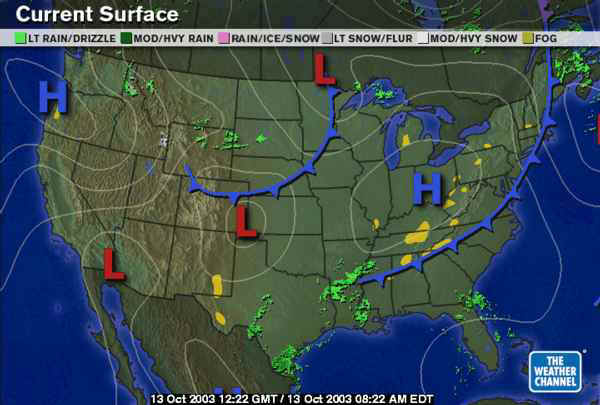
We had the weekend front pass and another High pressure system is moving in from the west brining more of this nice weather...for about 24 hours.
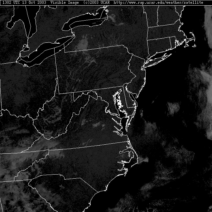
With the sun rising later (and setting earlier), this Visible Satellite view is suffering from a lower sun angle than we have seen in the summer mornings. The sun rises now about 7:09am this morning (compare that to 5:32am June 21st). This picture was taken at 1302UTC (so subtract 4 hours for daylight time and you get; 9:02am) which is only two hours after dawn. You can see bits of fog in the canyons of western Pennsylvania, but nothing near here.
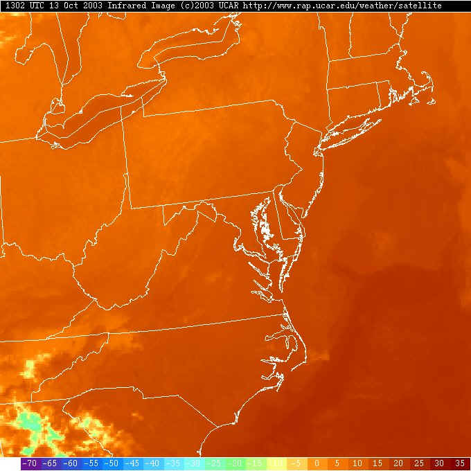
For that reason, the Infrared Satellite view is best. The earth is radiating away heat all the time - day and night. The hotter a place on the earth is, the more infrared radiation is emitted (remember your 'black body' lessons from high school?). So we look with infrared eyes at the earth from space and see the warmer oceans to the south (the Gulf Stream in deep red) and the Great Lakes glowing warmer than the surrounding morning cool lands (this will reverse as the day goes on and the land heats up more than the water does.
Clouds are much cooler (being higher in the atmosphere) and are colored as light yellow or even blues. There are only some clouds down in eastern Tennessee. You can't see the fog in the valleys of western Pennsylvania because fog is the same temperature as the ground (or VERY slightly cooler). It's just not easy to notice.
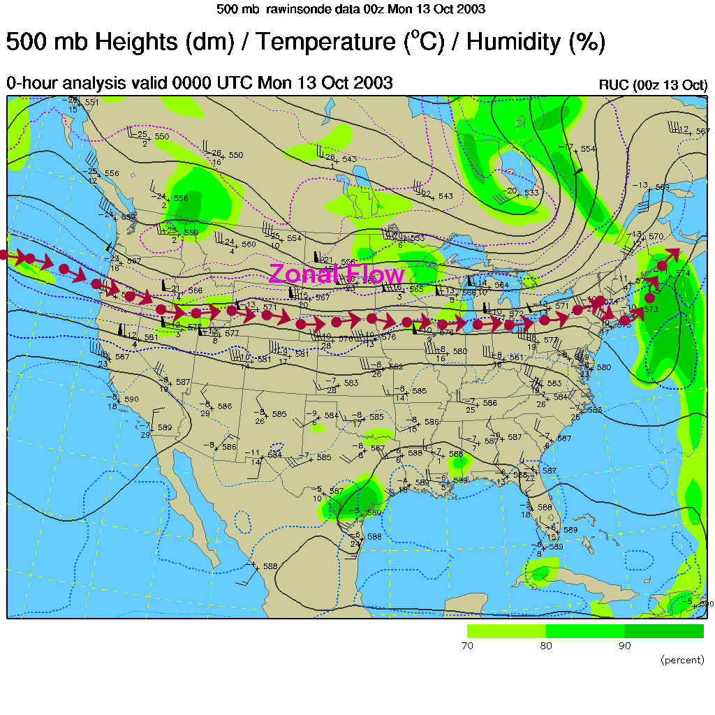
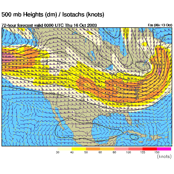
The winds on the 500mb map (which blow parallel to the dark black lines from mainly west to east across the US at about 18,000 feet above sea level) across the US are nearly STRAIGHT west to east. This is called zonal flow. Systems (fronts, lows) scoot rapidly across the US in such situations. The remains of the trough that moved the weekend front off into the ocean.
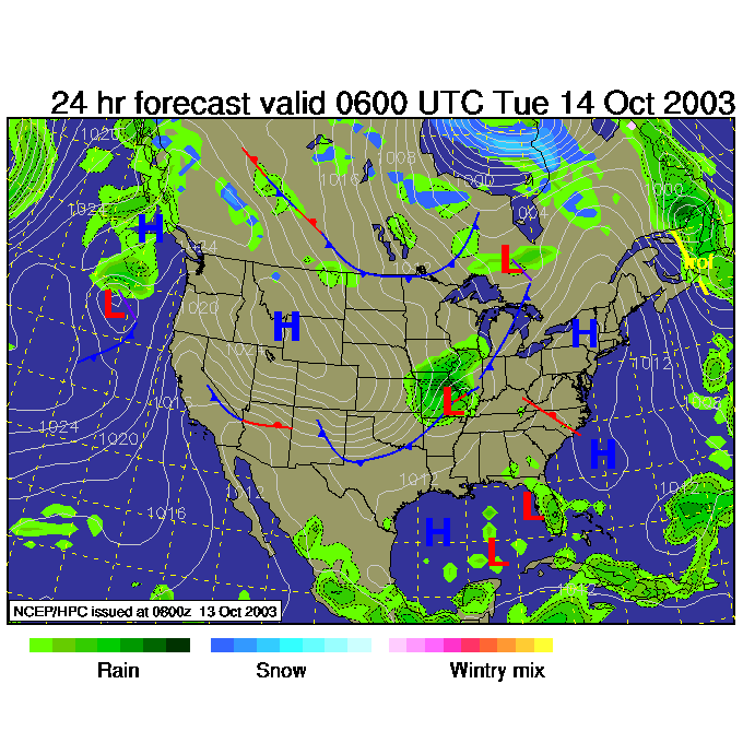
So tonight at 2am, we have a BRAND NEW Low forming on the front moving down the Plains and a nice cool High sitting on us.
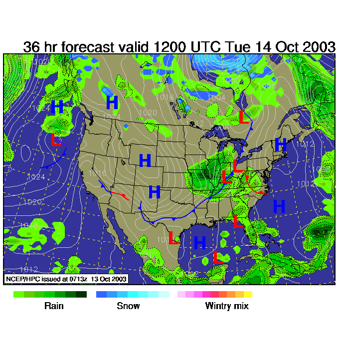
Tuesday morning, we see the new Low intensifying and moving QUICKLY towards us (sometimes it takes DAYS for this systems to move from the Mississippi River to Philadelphia, not this time!).
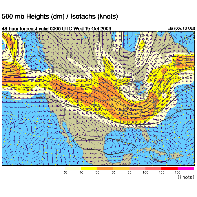
The 500mb flow has buckled in place over the Great Lakes and is shoving the front and Low eastward (and intensifying them).
Tuesday night and BOOM, here it is (it's like that scene from Monty Python's Holy Grail - where the knight is running up on the guards at the castle gate from across the field. And he's running...and still out there running - then HE'S THERE!).
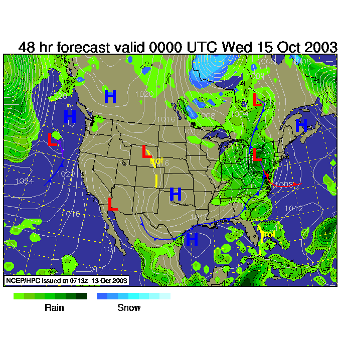
The Chance of rain Tuesday night shoots quickly up to the 70-90% zone.
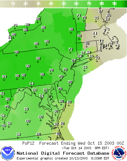
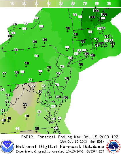
And is still a respectable (but dropping quickly after this) 70% by 8am Wednesday!
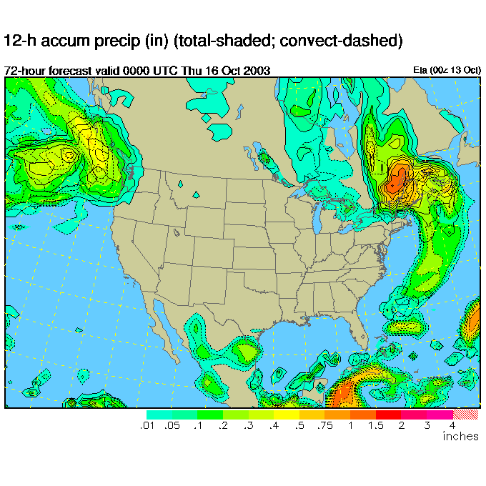
Then the trough that formed is already far out to sea...
And by Wednesday night, the rain is gone, gone gone.
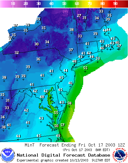
With the next High bringing clear skies and cool air in, the coolest night this week looks like Friday morning with lower 40's in the area. Nothing severe at all.
Enjoy the cool shockingly clear and cool weather!
Meteorologist John Ensworth
Surface Station sky cover color key:
Flight category definitions:| Category | Ceiling | Visibility | |
|---|---|---|---|
| Low Instrument Flight Rules LIFR* (magenta circle) |
below 500 feet AGL | and/or | less than 1 mile |
| Instrument Flight Rules IFR (red circle) |
500 to below 1,000 feet AGL | and/or | 1 mile to less than 3 miles |
| Marginal Visual Flight Rules MVFR (blue circle) |
1,000 to 3,000 feet AGL | and/or | 3 to 5 miles |
| Visual Flight Rules VFR+ (green circle) |
greater than 3,000 feet AGL | and | greater than 5 miles |
| *By definition, IFR is ceiling less than 1,000 feet
AGL and/or visibility less than 3 miles while LIFR
is a sub-category of IFR. +By definition, VFR is ceiling greater than or equal to 1,000 feet AGL and visibility greater than or equal to 3 miles while MVFR is a sub-category of VFR. |
|||