
Back To Home
The Story Behind the Weather - By Forecaster John
Ensworth M.S. -
The Discussion of Weather Events Daily for Philadelphia and Pennsylvania
Last updated: 11/28/2003 11:23 AM
Good Morning Philadelphia!
I'm glad to announce that these
discussions will continue until at least the end of
this Year!.
I
have the necessary server space.
In short: Wet and then a bit more wet then durn cold and wet. BUT my hints at Philadelphia snow will probably NOT pan out. Sorry, the west and north will see snow, but not us. Watch out for a powerful period of winds again after this low departs tonight and into tomorrow. It shouldn't be as bad as the last winterish wind storm, but will still snap some small branches.
Speaking of snow, there is a BIT of snow on the ground in the state as of a day ago (though the rain has probably destroyed it by now (see the dark purple shading on the map below).
And here IS the rain. There is a LOT of precipitation falling state wide and more moving in from the west. Notice the strange smoothness of the rain out over Ohio. This is a visual cue that something interesting is going on.

That interesting thing is FREEZING/FROZEN precipitation. If you mix in the vertical temperature structure of the atmosphere and the surface temperatures, the computer can color the rainfall to give a hint which is rain only (green), snow (blue), and a mix of rain and snow or possibly freezing rain (pink).
This is a hint of things to come for central and northern Pennsylvania, but we live at too low an altitude for rain and snow this storm.

So looking at the national map, you can see the big Low pressure system that is the center of this storm. There is a warm front to our south and rain wrapping counterclockwise around the system. There is snow out on the northern and western side of the system where the coldest air is feeding in from the north.

Zooming in on the northeast, you can see that real warmth is to the south and even if it passes to our north, the warming will be brief before the cold air pours in behind the low as it tracks to the east over our heads today and tonight. Rain, off and on, will be the story for us!

Looking at a bit more timely data, the low pressure center is in northwestern/central Pennsylvania right now. You can see the wind streaming in behind the low. These winds are expected to increase as the day goes on.

The temperatures reflect this wind flow above. Warm moist air is flooding northward ahead of the front and Low, and cold air is pouring in from the west and and northwest.

For travel today, the rain may cause moderate delays on east coast flights, but nothing really bad.

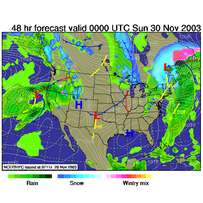
So looking into the future, by 7am Saturday, the low should be up to the north leaving New York state. You can see the front is off the coast and most of the rain is behind the front. Snow is falling over the northern and western 3/4ths of the state. We just have a very cold rain.

By Sunday 7pm, we still have a chance of rain across the state, but the area of precipitation should be confined to the higher elevations out west (rain and snow).
Have a great vacation weekend and I'll stop by tomorrow sometime and we'll see how much snow fell, and where.
Meteorologist John Ensworth
Surface Station sky cover color key:
Flight category definitions:| Category | Ceiling | Visibility | |
|---|---|---|---|
| Low Instrument Flight Rules LIFR* (magenta circle) |
below 500 feet AGL | and/or | less than 1 mile |
| Instrument Flight Rules IFR (red circle) |
500 to below 1,000 feet AGL | and/or | 1 mile to less than 3 miles |
| Marginal Visual Flight Rules MVFR (blue circle) |
1,000 to 3,000 feet AGL | and/or | 3 to 5 miles |
| Visual Flight Rules VFR+ (green circle) |
greater than 3,000 feet AGL | and | greater than 5 miles |
| *By definition, IFR is ceiling less than 1,000 feet
AGL and/or visibility less than 3 miles while LIFR
is a sub-category of IFR. +By definition, VFR is ceiling greater than or equal to 1,000 feet AGL and visibility greater than or equal to 3 miles while MVFR is a sub-category of VFR. |
|||