Back To Home
The Story Behind the Weather - By Forecaster John
Ensworth M.S. -
The Discussion of Weather Events Daily for Philadelphia and Pennsylvania
last updated: 09/14/2003 02:19 PM
Oh, my what a beautiful morning! This is quite a
change over the last few months of, well, constantly falling water.
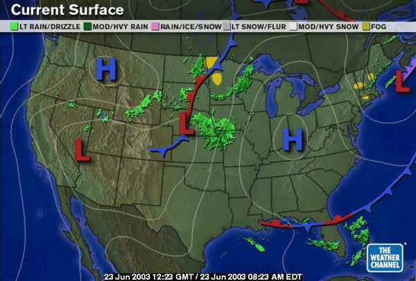
The low off the coast of Maine is pulling away with all it's water in tow. The
High over the Indiana/Ohio/Kentucky border is going to dominate our weather
through Wednesday. By Wednesday and Thursday it will pull off to the
south and a warm front will begin to
get it's act together over our state... but more about that at the bottom of
this duscussion.
The visible satellite picture shows very clear skies across
except for a few puffs of clouds in the central mountains and
a hint of some fog in the low lands in the south. There has been so much
moisture in the area that it is evaporating and
making the atmosphere more moist. In the morning, before the surface winds
kick up, this ground level air cools to
the dew point and dew and fog form
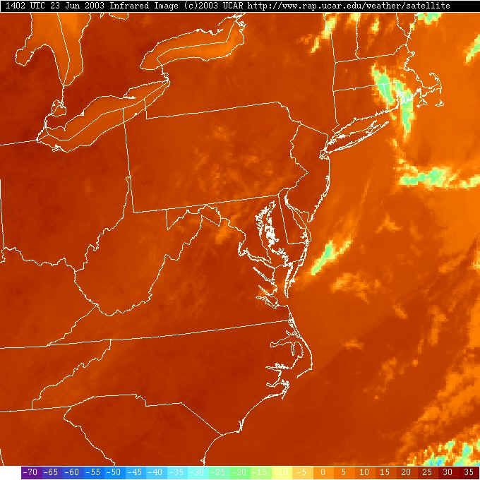
Looking at the infrared satellite picture (remember, this is
temperature that you are looking at) we can see the redder
colors to the west. This is the warmer/hotter air returning to the
northeastern US just in time to make the start of
summer (June 21st, this last Saturday) more real to us. You can see the
temperature of the Great Lakes and the Atlantic
are cooler (more orange/yellow) than the land. This picture late today
will be an even greater contrast.
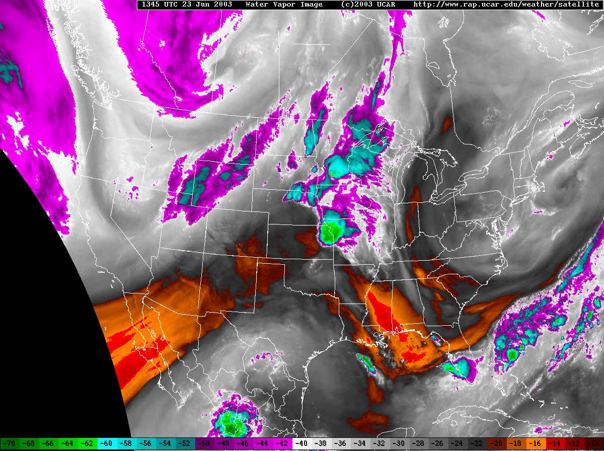
This new satellite view (to these discussions) is the water
vapor satellite picture. The reds are sinking (warming) dry air. The
grays and whites are very moist air in the middle atmosphere and the purples are
ice clouds and thick clouds. You can see that there is still
a good amount of moisture aloft over the entire northeast US. In fact, if
you go to the next image:
You can see in the 500mb map (the winds here at the 1/2 pressure level in the atmosphere run parallel to the dark black lines) looks just like the flow of moisture across the nation. These two maps match very closely. This map shows an upper level low just off Maine just like the surface map (this means the system is stacked vertically in the atmosphere ... which means it is dying. Bye bye! and good riddens!). I've drawn the approximate location of the jet stream in in purple arrows. North of the jet stream is where the cool/cold air resides, south of the jet stream is the home of the warm/hot air. We are definitely south of the main jet. We just need to see this last piece of the low pull out. While it is still over our heads, there is cool air up above us, so the forecast includes a chance of an afternoon thunderstorm. When we get surface temperatures as high as they will go today, the cold air aloft might allow random thunderstorms to pop up. Us meteorologists need to cover the bases like this sometimes.
So with the high to our southwest, and with air always
flowing clockwise around a high pressure system, we have winds picking up
from the west blowing out to sea. This will keep the cool sea breeze at
bay (keep it from approaching the shore until later in the day, and then not
allow it to progress very far westward, inland). The flags on each
station point show the wind direction by noting that
the wind blows from the flags on the sticks to the station circles (key to the
sky conditions coded in the circles is included at the
very bottom of the page). The upper left number (in red) is the
current temperature, the lower left number (in green) is the dew point - or a
statement of how much water there is in the air. So we have upper 70's
already in place with 90's expected by later in the day.
But the dew points are low (40's and 50's is a bit dry to fairly normal) so the
heat won't be to bad yet, still, we are not used to 90's (this is the first time
since last summer we have been this warm). Take it easy with outdoor
activity this afternoon.

Taking a glimpse into the future, using the GFS model, we can
see a slight chance of showers in the area Wednesday night (this
forecast is for 8pm Wednesday - remember, subtract 4 hours from the
"Z" time printed on the maps). It won't be much or
widespread.
Jumping forward to Thursday 8am, you can see the next batch
of rain for the end of the week/start of the weekend approaching
from the west, but we still have only a small chance of rain locally.
So enjoy those blue skies and warm temperatures. Maybe some of the mold will die. Maybe.
;-)
Meteorologist John Ensworth
Surface Station sky cover color key:
Flight category definitions:| Category | Ceiling | Visibility | |
|---|---|---|---|
| Low Instrument Flight Rules LIFR* (magenta circle) |
below 500 feet AGL | and/or | less than 1 mile |
| Instrument Flight Rules IFR (red circle) |
500 to below 1,000 feet AGL | and/or | 1 mile to less than 3 miles |
| Marginal Visual Flight Rules MVFR (blue circle) |
1,000 to 3,000 feet AGL | and/or | 3 to 5 miles |
| Visual Flight Rules VFR+ (green circle) |
greater than 3,000 feet AGL | and | greater than 5 miles |
| *By definition, IFR is ceiling less than 1,000 feet
AGL and/or visibility less than 3 miles while LIFR
is a sub-category of IFR. +By definition, VFR is ceiling greater than or equal to 1,000 feet AGL and visibility greater than or equal to 3 miles while MVFR is a sub-category of VFR. |
|||