
Back To Home
The Story Behind the Weather - By Forecaster John
Ensworth M.S. -
The Discussion of Weather Events Daily for Philadelphia and Pennsylvania
Last updated: 09/14/2003 02:34 PM
Good Afternoon Philadelphia!
Due to a completely dead network locally, I'm late getting data up today. I apologize.
As I write, storms are wandering around the state...let's check in on them...
There is the cold front mentioned yesterday pushing down out of Canada towards us. Numerous showers and storms are popping up ahead of it in the deep tropical moisture that has returned.
The Severe Storms Prediction Center (SPC) is holding out for a Slight Chance of severe storms over much of Pennsylvania, but not exactly in Philadelphia.

Storms are firing up and moving fairly quickly to the east-southeast. We may get hit by more showers at any time tonight.
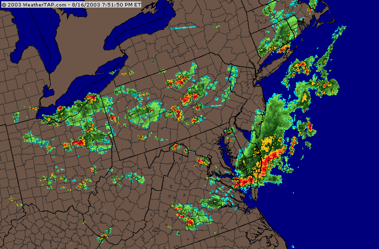
Currently there are a couple storms that have reached Severe levels up north and out west. Even though the SPC has us outside the Slight Risk, we could get a severe bout of weather. Keep an eye on the TV or web tonight.
![]()
![]()
![]()

The storms over the last day have only sprinkled on Philadelphia, but up to 5+ inches have hit in some locations. These storms can dump a LOT of water.

The visible satellite picture at this late hour in the evening is showing nearly nothing. Only the highest clouds are still poking up into the sunlight. This is another reason the infrared satellite view is so valuable...

The IR Satellite view shows the highest (and therefore coldest) cloud tops as blue colors on the map. This works all night whereas the Visible satellite view is gone about this time each day.

The winds at about 18,000 feet (the 500mb map below) show a trough reforming over the eastern US that is associated with the descending front and our return to unsettled weather for now. The central US is about to bake in summer heat with the big ridge out there (both marked).

The forecast is as follows... The trough on the east coast will get bigger while the ridge on the Great Plains is only dampened by the smaller trough over the Rockies. Believe it or not, this Rockies trough is the piece of our OLD trough that broke off and went southwest across Texas earlier this last week. It has brought rain to Arizona and Southern California, and is now rejoining the flow in the northern US and is beginning to head east again. Strange weather things... no?

The surface front is moving out by Sunday afternoon, but the developing Low to our southeast may kick some moisture around to the northwest and hit us for a continued chance of showers.

Monday morning see's that Rockies trough still wandering around out there and the east coast trough barely a bit further east.

The front hasn't moved much, but probably enough to dry us out...mostly.

Looking way out to Wednesday morning, the upper level map shows the Rockies trough beginning to progress eastward as our area is dominated again by a building ridge and warmer drier weather again. This is a progressive pattern with nothing staying still too long. That's nice for variety.

That's all for today, I'll see you again here Monday. Until then, keep looking up and stay dry!
Meteorologist John Ensworth
Surface Station sky cover color key:
Flight category definitions:| Category | Ceiling | Visibility | |
|---|---|---|---|
| Low Instrument Flight Rules LIFR* (magenta circle) |
below 500 feet AGL | and/or | less than 1 mile |
| Instrument Flight Rules IFR (red circle) |
500 to below 1,000 feet AGL | and/or | 1 mile to less than 3 miles |
| Marginal Visual Flight Rules MVFR (blue circle) |
1,000 to 3,000 feet AGL | and/or | 3 to 5 miles |
| Visual Flight Rules VFR+ (green circle) |
greater than 3,000 feet AGL | and | greater than 5 miles |
| *By definition, IFR is ceiling less than 1,000 feet
AGL and/or visibility less than 3 miles while LIFR
is a sub-category of IFR. +By definition, VFR is ceiling greater than or equal to 1,000 feet AGL and visibility greater than or equal to 3 miles while MVFR is a sub-category of VFR. |
|||