
Back To Home
The Story Behind the Weather - By Forecaster John
Ensworth M.S. -
The Discussion of Weather Events Daily for Philadelphia and Pennsylvania
Last updated: 09/15/2003 09:47 AM
Good Evening Philadelphia!
What do we have today? A tropical system, a mid- latitude system (a common front that moves west to east across the nation), then a tropical system again. Be prepared for excitement.
I'll get to Isabel, but you should go up a notch in awareness about that major and dangerous storm now. The east coast is -most certainly- going to be it's landing platform.
The visible satellite view, showing the remains of T.S. Henri (from the last week beginning Sept 3rd in the Gulf) moving in. The fuzzy looking clouds over Pennsylvania are called cirrus and are the signs of things to come. The center of circulation is still over the ocean to our south/southeast. You can see the clumpier looking clouds down there. Those are thunderstorms (or cumulonimbus clouds) as the system feeds on the warm ocean water.
You can see it's center as shown on the surface map with a big red 'L'. Rain is spreading northward around the east side of the center of circulation (remember, air rotates in a counterclockwise direction around Low's).

The radar image shows rain already starting on land. I've drawn arrows showing cell motion in different points of the mass of rain. Light rain is spreading towards us, but the heavier storms are spiraling around the center of circulation to the right and a bit to the south (too bad we can't do loops here... yet).

As warned about yesterday, the northeast onshore winds are increasing. Waves will be big - especially at high tide.

The 500mb map shows the wind flow at approximately 18,000 feet above sea level. It is really a map of how high in the atmosphere you need to go to find the air pressure reduced to 1/2 of sea level pressure. If you don't have to go very high, then the air is probably cool and dense and you are in a trough (such as is located over western Canada down into Montana and the Dakotas). If you have to go very high into the atmosphere, then you have (probably) warm air that is less dense. The winds at this level tend to steer storms and blow parallel mainly from west to east across the U.S.
I've drawn in the wind directions at this level with small blue lines (near Pennsylvania). You can see the axis of the Big Ridge marked with the red text. The remains of Henri will follow that 'uphill' side of the ridge and slide right over us.

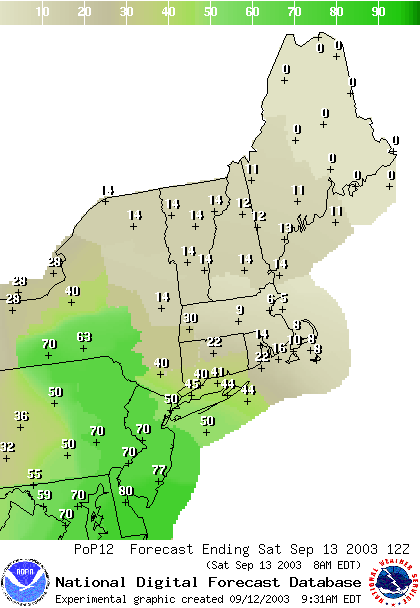
From the National Weather Service, I have a string of the probability of precipitation maps they now generate. A 5% chance of rain is going to be dry most of the time. An 80% chance of rain is a good reason to cancel a planned picnic.
You can see the chances of rain moving in rapidly today (this is for Friday afternoon/evening).

Overnight up to Saturday morning, you can see the rain spreading in fast.
We're still very wet on the day Saturday from Henri remains.

Overnight Saturday into Sunday morning you can see the biggest chance of rain from this system finally moving off to the northeast.

As you'll see below, a front from the Plains approaches rapidly on the heals of Henri and further 'wettens' up the ground. Then all eyes must turn to the eye in the ocean... Cat 5 Hurricane Isabel. It too will want to follow that 500mb pattern above (which will change some by the time it gets here) and will gain a NW directed component to its movement as it gets closer to the US.

The projected path is now endangering the entire southern half of the US east coast. If it hits anywhere here, we will get the remains while there is still a lot of punch to them. And the bad news is, our soil is already wet from months of above normal precipitation and now a couple more hits of new water. Flooding could be catastrophic for those hit by this!!!

So let's see what the computer model called the GFS paints this next week's story (this is the first full run of the GFS I've featured here. Forecasts here are subject to error (and more error as you go further into the future).
You can see the blob of rain to our south with Henri this morning and the front in the plains.

By tonight, 8pm, the rain is here, and the front slips closer.

Saturday 8am, we are still under the Henri rain 'bands' and the front is forming a new low on it over eastern Oklahoma.

The rain starts to fall apart by 8am Sunday around here, and the front in the plains gets moving eastward again. Isabel can be seen entering the frame in the distant lower right.

We still have a chance of rain here from the tropical feed of moisture Henri pulls up, the front is now into the Ohio valley kicking up showers, and Isabel eyes the coast from the southeast. (Monday 8am)

Now the frontal system moves into the state (and pulls northward). If this front could have established itself (with a upper level or 500mb trough overhead) it could have kept Isabel away, but it is moving up to the north as it passes. The southeast coast is being opened up for a hurricane hit. (Tuesday 8am)

Now the front is thinning out just on the coast to our east, and Isabel is turning northwestward. (Wednesday 8am)

Our front is gone, and Isabel moves in for the kill. (Thursday 8am)

And at this time, the GFS is forecasting (a LONG WAY away - next Friday morning!) a hit on the North Carolina/Virginia/Delaware coast.

Stay tuned!
We'll keep an eye on all this together! Until tomorrow... enjoy the dryth. (I know it's not a word.)
Meteorologist John Ensworth
Surface Station sky cover color key:
Flight category definitions:| Category | Ceiling | Visibility | |
|---|---|---|---|
| Low Instrument Flight Rules LIFR* (magenta circle) |
below 500 feet AGL | and/or | less than 1 mile |
| Instrument Flight Rules IFR (red circle) |
500 to below 1,000 feet AGL | and/or | 1 mile to less than 3 miles |
| Marginal Visual Flight Rules MVFR (blue circle) |
1,000 to 3,000 feet AGL | and/or | 3 to 5 miles |
| Visual Flight Rules VFR+ (green circle) |
greater than 3,000 feet AGL | and | greater than 5 miles |
| *By definition, IFR is ceiling less than 1,000 feet
AGL and/or visibility less than 3 miles while LIFR
is a sub-category of IFR. +By definition, VFR is ceiling greater than or equal to 1,000 feet AGL and visibility greater than or equal to 3 miles while MVFR is a sub-category of VFR. |
|||