Back To Home
The Story Behind the Weather - By Forecaster John
Ensworth M.S. -
The Discussion of Weather Events Daily for Philadelphia and Pennsylvania
Last updated: 09/17/2003 09:52 AM
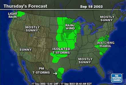
Good Morning Philadelphia!
There is much to talk about today, and little to talk
about. Isabel is the story right now.
To cut through all the confusion, let's look at the expected
hour by hour forecast from www.accuweather.com
:
This Sequence begins THURSDAY 2pm. Isabel has already
made landfall in the early morning probably in North Carolina and is being torn
up by land and mountains as it goes into Virginia and W. Virginia.
There is a lot of information here, but the most important
bit (aside from the unbelievable amounts of rain that will be falling for hours
and hours) are the winds at the bottom of the column. Here winds are
expected to stay in the upper 20mph region through 10pm with gusts into the
40mph realm.
|
TIME
|
2pm
|
3pm
|
4pm
|
5pm
|
6pm
|
7pm
|
8pm
|
9pm
|
10pm
|
|

|
|
|
|
|
|
|
|
|
|
|
Weather
Conditions
|

|
|
|
|
|
|

|
|
|
|

|
|
|
|
|
|
|
|
|
|
|
Cloud
Cover
(%)
|
90%
|
90%
|
90%
|
90%
|
90%
|
92%
|
95%
|
97%
|
98%
|
|

|
|
|
|
|
|
|
|
|
|
|
Ceiling
Height
(ft.x100)
|
20
|
20
|
20
|
20
|
15
|
11
|
7
|
7
|
7
|
|

|
|
|
|
|
|
|
|
|
|
|
Visibility
(mi.)
|
10.0
|
5.0
|
5.0
|
5.0
|
5.0
|
5.0
|
4.0
|
4.0
|
4.0
|
|

|
|
|
|
|
|
|
|
|
|
|
UV
Index
(1-10+)
|
1
|
1
|
0
|
0
|
0
|
0
|
0
|
0
|
0
|
|

|
|
|
|
|
|
|
|
|
|
|

|
|

|
|
|
|
|
|
|
|
|
|
|
Temperature
(°F)
|
72
|
73
|
72
|
70
|
68
|
68
|
67
|
66
|
66
|
|

|
|
|
|
|
|
|
|
|
|
|
Realfeel
Temp(tm)
(°F)
|
69
|
69
|
68
|
66
|
64
|
64
|
63
|
62
|
62
|
|

|
|
|
|
|
|
|
|
|
|
|
Dewpoint
(° F)
|
63
|
64
|
64
|
64
|
64
|
66
|
66
|
65
|
65
|
|

|
|
|
|
|
|
|
|
|
|
|
Relative
Humidity
(%)
|
73
|
75
|
77
|
81
|
87
|
93
|
97
|
97
|
97
|
|

|
|
|
|
|
|
|
|
|
|
|

|
|

|
|
|
|
|
|
|
|
|
|
|
Precipitation
Type
|
Rain
|
Rain
|
Rain
|
Rain
|
Rain
|
Rain
|
Rain
|
Rain
|
Rain
|
|

|
|
|
|
|
|
|
|
|
|
|
1
hr Snowfall
(in)
|
0.0
|
0.0
|
0.0
|
0.0
|
0.0
|
0.0
|
0.0
|
0.0
|
0.0
|
|

|
|
|
|
|
|
|
|
|
|
|
1
hr Icefall
(in)
|
0.00
|
0.00
|
0.00
|
0.00
|
0.00
|
0.00
|
0.00
|
0.00
|
0.00
|
|

|
|
|
|
|
|
|
|
|
|
|
1
hr Rainfall
(in)
|
0.05
|
0.05
|
0.05
|
0.05
|
0.05
|
0.07
|
0.07
|
0.07
|
0.07
|
|

|
|
|
|
|
|
|
|
|
|
|
1
hr Liquid Equiv.
(in)
|
0.05
|
0.05
|
0.05
|
0.05
|
0.05
|
0.07
|
0.07
|
0.07
|
0.07
|
|

|
|
|
|
|
|
|
|
|
|
|

|
|

|
|
|
|
|
|
|
|
|
|
|
Wind
Direction
|

ENE
|
ENE
|
ENE
|
ENE
|
ENE
|
ENE
|
ENE
|
ENE
|
ENE
|
|

|
|
|
|
|
|
|
|
|
|
|
Wind
Speed
(mph)
|
21
|
21
|
22
|
23
|
23
|
23
|
27
|
25
|
24
|
|

|
|
|
|
|
|
|
|
|
|
|
Wind
Gust
(mph)
|
35
|
37
|
39
|
40
|
40
|
39
|
42
|
38
|
33
|
The next jump goes from 10pm Thursday night to 6 am
Friday morning. The storm will be largely past us by then. Winds
remain steady in the 20mph realm with gusts into the 30mph area.
These are not damaging winds and it will be the 3-6" or more of rain we'll
need to worry about. YESTERDAY this same forecast showed 100mph winds in
the Philadelphia and since the storm has not YET hit land, it is possible that
it will curve a bit to the east at the last moment, head up the Chesapeake Bay
and roar into our city with a LOT of force, and, as I will show below, there is
one computer model showing that STILL happening.
|
TIME
|
10pm
|
11pm
|
12am
|
1am
|
2am
|
3am
|
4am
|
5am
|
6am
|
|

|
|
|
|
|
|
|
|
|
|
|
Weather
Conditions
|
|
|
|
|

|
|
|
|
|
|

|
|
|
|
|
|
|
|
|
|
|
Cloud
Cover
(%)
|
98%
|
99%
|
98%
|
97%
|
95%
|
93%
|
91%
|
89%
|
88%
|
|

|
|
|
|
|
|
|
|
|
|
|
Ceiling
Height
(ft.x100)
|
7
|
7
|
5
|
4
|
3
|
4
|
5
|
7
|
7
|
|

|
|
|
|
|
|
|
|
|
|
|
Visibility
(mi.)
|
4.0
|
4.0
|
5.0
|
5.0
|
5.0
|
8.0
|
6.0
|
4.0
|
4.0
|
|

|
|
|
|
|
|
|
|
|
|
|
UV
Index
(1-10+)
|
0
|
0
|
0
|
0
|
0
|
0
|
0
|
0
|
0
|
|

|
|
|
|
|
|
|
|
|
|
|

|
|

|
|
|
|
|
|
|
|
|
|
|
Temperature
(°F)
|
66
|
67
|
67
|
68
|
68
|
68
|
67
|
67
|
65
|
|

|
|
|
|
|
|
|
|
|
|
|
Realfeel
Temp(tm)
(°F)
|
62
|
63
|
64
|
64
|
64
|
65
|
64
|
63
|
62
|
|

|
|
|
|
|
|
|
|
|
|
|
Dewpoint
(° F)
|
65
|
66
|
66
|
67
|
67
|
67
|
67
|
66
|
65
|
|

|
|
|
|
|
|
|
|
|
|
|
Relative
Humidity
(%)
|
97
|
97
|
97
|
97
|
98
|
98
|
98
|
98
|
98
|
|

|
|
|
|
|
|
|
|
|
|
|

|
|

|
|
|
|
|
|
|
|
|
|
|
Precipitation
Type
|
Rain
|
Rain
|
Rain
|
Rain
|
--
|
--
|
--
|
--
|
--
|
|

|
|
|
|
|
|
|
|
|
|
|
1
hr Snowfall
(in)
|
0.0
|
0.0
|
0.0
|
0.0
|
0.0
|
0.0
|
0.0
|
0.0
|
0.0
|
|

|
|
|
|
|
|
|
|
|
|
|
1
hr Icefall
(in)
|
0.00
|
0.00
|
0.00
|
0.00
|
0.00
|
0.00
|
0.00
|
0.00
|
0.00
|
|

|
|
|
|
|
|
|
|
|
|
|
1
hr Rainfall
(in)
|
0.07
|
0.07
|
0.07
|
0.07
|
0.00
|
0.00
|
0.00
|
0.00
|
0.00
|
|

|
|
|
|
|
|
|
|
|
|
|
1
hr Liquid Equiv.
(in)
|
0.07
|
0.07
|
0.07
|
0.07
|
0.00
|
0.00
|
0.00
|
0.00
|
0.00
|
|

|
|
|
|
|
|
|
|
|
|
|

|
|

|
|
|
|
|
|
|
|
|
|
|
Wind
Direction
|
ENE
|
ENE
|
ENE
|
ENE
|
ENE
|
ENE
|
ENE
|
ENE
|

E
|
|

|
|
|
|
|
|
|
|
|
|
|
Wind
Speed
(mph)
|
24
|
22
|
23
|
24
|
24
|
23
|
22
|
21
|
19
|
|

|
|
|
|
|
|
|
|
|
|
|
Wind
Gust
(mph)
|
33
|
29
|
30
|
31
|
32
|
31
|
29
|
27
|
25
|
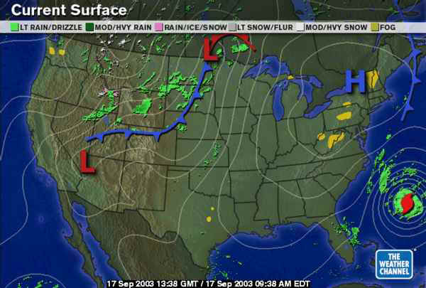
A quick look at the surface map shows the front we had pass a
few days ago has (as advertised)
vanished in the sinking air and new air flow around approaching Isabel.
Isabel is easily visible churning away east of S. Carolina this morning.
Something interesting to note is the big High pressure system over New York
State behind that front. This High will actually matter as much as the
hurricane to us IF the hurricane doesn't hit us straight on but goes to the west
as is now expected. More on this High at the bottom.
Here is Isabel this morning. It has a hint of an eye
and a very classic structure.
The strike probability map shows the National Weather Service
thinking. It is expecting the most likely path to remain to the west of
Philadelphia proper, but we will still get some serious weather out of this...
and a more direct strike is not impossible ... yet.
Here are the expected path's of the eye from a number of
different computer models. The BAM Medium (yellow) path could bring 100mph
winds to our city... every other model is further west... but it's not over for
us yet for a direct hit.
Historically we have NEVER had a hurricane strike from this location
in the ocean (since we've been making observations). We don't really have
a precedent to go by EXCEPT the storms 'like' to curve to the east when on this
kind of path (which would be bad for us).
The wind field around the hurricane shows a greater 100 mile
radius of hurricane force winds. This is a BROAD area under damaging
winds. Landfall will not be pretty (probably in N. Carolina).
Looking closer to the NWS forecast, they have the eye almost
going directly over College Station (making meteorologists there happy). But
note, we are still in the envelope of possibilities.
Just for fun, you can see what it is expected to do after
sliding through our state... it may skirt Hudson Bay. Canada and
hurricanes. It almost seems like an oxymoron.
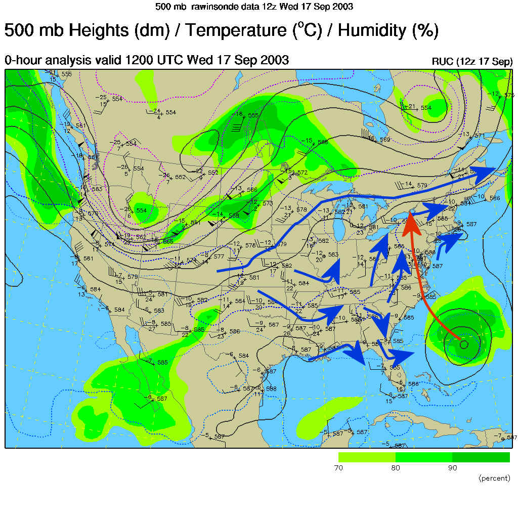
The 500mb map (which shows the air flow at about 18,000 feet
above sea level) shows us the winds most likely to steer the hurricane.
I've included many blue arrows showing the weak and variable flow in the SE US
ahead of Isabel (giving forecasters a headache). The red path is the most likely
track. You can see the winds do, sort of, get their act together and begin
pushing the storm to the east the further north it goes. After that (north
of us) it is really getting a push to the east.
Now to the winds. This graphic shows the past life of
the storm. The Orange envelope is where tropical force storm winds happened
(winds between about 35mph and 74mph). The Red areas show hurricane force
winds (greater than 74mph). The storm was Cat 5 for much of the middle of
this path. At that time the wind swath was smaller and tighter. It is
expanding in coverage now even though the winds have dropped to Cat 2 strength
this morning (about 110mph). There still is as much energy in that sense,
weaker winds but over a MUCH larger area. This storm has a punch.
This graph from the National Hurricane Center tries to
predict the maximum winds over time (with a big envelope for error). The
blue line down the middle is their most confident forecast. The storm will
be on a level with Philadelphia at about 48 hours (or a bit earlier). That
means winds could be as low as 35mph and as high as 100mph with the most likely
wind strength being about 65mph. IF it hits us head on, we will see some
widespread damage and downed trees and power lines across the city.
Even if it stays on track and moves toward west central
Pennsylvania, that High pressure system to our north will make a very tight
"Pressure Gradient" over the northern east coast. I've drawn in
red arrows showing the wind direction around the two systems - and it is STRONG
and onshore. On the map, where the white lines are the tightest together,
the wind is the strongest (see the center of Isabel). We (in the purple
circle) still get a very strong wind over the area with high seas and beach erosion
out at the ocean.
So to wrap it up, Thursday and Thursday night we get landfall
of Isabel (thankfully and hopefully) to our south, and rain and winds rapidly
pick up in Philadelphia.
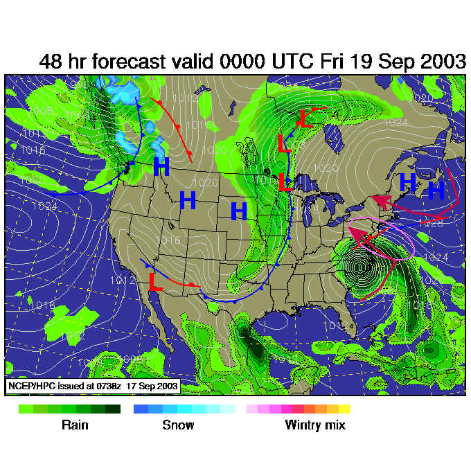
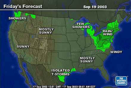
Overnight, the bulk of the storm passes and by Friday
morning, the storm is pulling out and we return to some very nice weather quite
quickly.
Watch the news and listen to the radio and be ready to take a
direct hit. Again, we are not QUITE out of the woods until the storm hits
land.
Meteorologist John Ensworth
Surface Station sky cover color key:
Flight category definitions:
| Category |
Ceiling |
|
Visibility |
Low Instrument Flight Rules
LIFR* (magenta circle) |
below 500 feet AGL |
and/or |
less than 1 mile |
Instrument Flight Rules
IFR (red circle) |
500 to below 1,000 feet AGL |
and/or |
1 mile to less than 3 miles |
Marginal Visual Flight Rules
MVFR (blue circle) |
1,000 to 3,000 feet AGL |
and/or |
3 to 5 miles |
Visual Flight Rules
VFR+ (green circle) |
greater than 3,000 feet AGL |
and |
greater than 5 miles |
*By definition, IFR is ceiling less than 1,000 feet
AGL and/or visibility less than 3 miles while LIFR
is a sub-category of IFR.
+By definition, VFR is ceiling greater than or equal to 1,000 feet
AGL and visibility greater than or equal to 3 miles while MVFR is a
sub-category of VFR. |