
Back To Home
The Story Behind the Weather - By Forecaster John
Ensworth M.S. -
The Discussion of Weather Events Daily for Philadelphia and Pennsylvania
Last updated: 09/14/2003 02:40 PM
Good Afternoon Philadelphia!
When you read this, these discussions should be posted on their new home at earthlink. Our server has probably died the big death. There goes thousands of dollars of old computer!
Anyway, we have a lot of weather to talk about. Temperatures across the region are climbing into the lower 80's to the south and east of us with 70's across the rest of the state. Being down on the coastal plain, it is almost like being in another state - weatherwise!
We do have a Flood Watch issued for the region with the fronts nearby and passing. We just keeping getting rain.

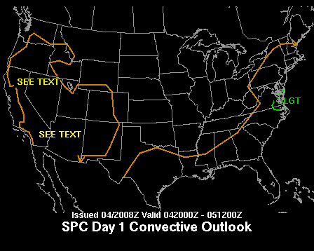
In fact, the Storm Prediction Center has a slight risk of severe weather just to our south...things could get borderline strong here as well (when the next front passes).
Still adding up the rainfall, since rain began falling in our vicinity about four days ago, we are pretty uniformly up to the 2" mark.

On the Weather Channel surface map, we have a cold front pressing towards us with a warm front far to the north.

When we look at the winds, we still see a south west, west, and northwest winds across our neighborhood.

And looking closer at the surface map, we still see the three air masses described yesterday . The heaviest storms are ahead of the eastern front where the deepest tropical moisture is, but there is still enough moisture left to make a thin line of storms along the new front approaching from the northwest.

You can even see the fronts in the visible satellite pictures. The southwest wind area has thick continuous clouds, the west wind slice has more broken cloud patterns, and the northwest wind region is partly clear.

The second front is visible as a knife thin line of thunderstorms sliding through central PA. Expect rain later tonight as this line passes and brings a new shot of cooler drier air back again.

A few days ago, we had troughs (blue lines) over ridges (red lines) across the nation, now we have two really big features - one big trough in the eastern US, and one big ridge in the central and western US. There are some small short waves in the flow (either side of the small ridge marked above, and at the bottom of the trough in the east. These can kick off more storms once they pass over surface fronts. (Remember, this is the air flow west to east parallel to the dark lines across the US at about 18,000 feet above sea level).
This big east coast trough is what is saving us from hurricane Fabian (more on that below).

Hurricane Fabian is now a Cat 3 storm with winds at 120mph. It will get picked up by our trough and roar off to the northeast out to sea (to eventually effect Europe!).

But closer to home, we do have a new tropical system popping up in the Gulf. It is expected to become a tropical storm soon and follow the east coast. Philadelphia is under the window of future movement of this system. We could see a tremendous amount of rainfall by mid-week next week if this stays to the west. We'll follow this as time goes by.

In the near future, the front approaching us is sliding off the coast and with it, the rain leaves. This map is valid for Friday at 2pm.

Later Friday (8pm) you can see Fabian straight east of the Carolinas heading north to northeast. Bermuda could be in SERIOUS trouble at this time. Also, the system in the Gulf is moving across northern Florida.

The high is parked on us with the coolest nights in a long time happening over the weekend. The front is far to the east (as is our trough in the upper atmosphere). Hurricane Fabian is heading northeast, and our tropical system is emerging into the Atlantic off Jacksonville, FL. Will it form into something worse than it is? Maybe... maybe...

See ya Friday AM! Until then, take care and stay dry!
Meteorologist John Ensworth
Surface Station sky cover color key:
Flight category definitions:| Category | Ceiling | Visibility | |
|---|---|---|---|
| Low Instrument Flight Rules LIFR* (magenta circle) |
below 500 feet AGL | and/or | less than 1 mile |
| Instrument Flight Rules IFR (red circle) |
500 to below 1,000 feet AGL | and/or | 1 mile to less than 3 miles |
| Marginal Visual Flight Rules MVFR (blue circle) |
1,000 to 3,000 feet AGL | and/or | 3 to 5 miles |
| Visual Flight Rules VFR+ (green circle) |
greater than 3,000 feet AGL | and | greater than 5 miles |
| *By definition, IFR is ceiling less than 1,000 feet
AGL and/or visibility less than 3 miles while LIFR
is a sub-category of IFR. +By definition, VFR is ceiling greater than or equal to 1,000 feet AGL and visibility greater than or equal to 3 miles while MVFR is a sub-category of VFR. |
|||